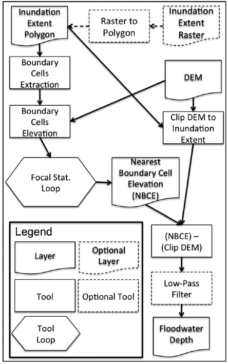
Information on flood inundation extent is important for understanding societal exposure, water storage volumes, flood wave attenuation, future flood hazard, and other variables. A number of organizations now provide flood inundation maps based on satellite remote sensing. These data products can efficiently and accurately provide the areal extent of a flood event, but do not provide floodwater depth, an important attribute for first responders and damage assessment. We develop a new methodology and a GIS-based tool, the Floodwater Depth Estimation Tool (FwDET), for estimating floodwater depth based solely on an inundation map and a Digital Elevation Model (DEM).
- FwDET_ArcGISProTool_DemoData
- Tool Code and Description on the CSDMS Repository
- Tool Code and Demo Data on GitHub
- Google Earth Engine Code
Tool DOI: 10.5281/zenodo.1119066
Papers
- Peter, B.G., S. Cohen, R. Lucey, D. Munasinghe, A. Raney, G.R. Brakenridge, (2020). Google Earth Engine Implementation of the Floodwater Depth Estimation Tool (FwDET-GEE) for Rapid and Large Scale Flood Analysis. IEEE Geoscience and Remote Sensing Letters. https://doi.org/10.1109/LGRS.2020.3031190
- Cohen, S., A. Raney, D. Munasinghe, J.D. Loftis J, A. Molthan, J. Bell, L. Rogers, J. Galantowicz, G.R. Brakenridge7, A.J. Kettner, Y. Huang, Y. Tsang, (2019). The Floodwater Depth Estimation Tool (FwDET v2.0) for Improved Remote Sensing Analysis of Coastal Flooding. Natural Hazards and Earth System Sciences, 19, 2053–2065. https://doi.org/10.5194/nhess-19-2053-2019 [pdf]
- , , , , , , , , and 2018), Estimating Floodwater Depths from Flood Inundation Maps and Topography, Journal of the American Water Resources Association, 54 (4), 847–858. doi:10.1111/1752-1688.12609 [pdf]