Our research focuses on Computational Modeling and Geospatial Analysis (GIS and Remote Sensing) across multiple Environmental Science themes, including Geomorphology, Hydrology, Natural Disasters and Human–Environment Interactions.
Major Research Themes
Flood Forecasting and Remote Sensing
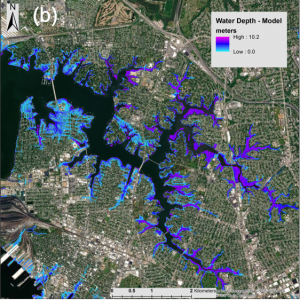
Flood forecasting and response require state-of-the-art hydrological models, high-quality observational data and advanced tools for data analysis and dissemination. Our research seeks to advance several aspects of the Disaster-Response paradigm: enhance continental-scale hydrological modeling by improving the morphological representation of rivers and their floodplains, enhance near-real-time flood mapping through remote sensing, and develop Cyberinfrastructure and Web Applications for seamlessly disseminating hydrological predictions and flood maps.
We developed a novel methodology for rapid calculation of Floodwater Depth from remote sensing derived flood maps. The Floodwater Depth Estimation Tool (FwDET) is disseminated as an open-source suite of tools and applications, including Python Scripts, ArcGIS and QGIS Tools and a Google Earth Engine repository. We develop and maintain a Web Portal (WaterServ) for dissemination of diverse applications and datasets, including the U.S. Flood Inundation Map Repository (USFIMR).
Selected Publications
- Cohen, S., B.G. Peter, A. Haag, D. Munasinghe, N. Moragoda, A. Narayanan, S. May, (2022). Sensitivity of Remote Sensing Floodwater Depth Calculation to Boundary Filtering and Digital Elevation Model Selections. Remote Sensing, 14, 5313. https://doi.org/10.3390/rs14215313 [pdf]
- Peter, B.G., S. Cohen, R. Lucey, D. Munasinghe, A. Raney, G.R. Brakenridge, (2020). Google Earth Engine Implementation of the Floodwater Depth Estimation Tool (FwDET-GEE) for Rapid and Large Scale Flood Analysis. IEEE Geoscience and Remote Sensing Letters.
- Anni, A. H., S. Cohen, S. Praskievicz, (2020). Sensitivity of Urban Flood Simulations to Stormwater Infrastructure and Soil Infiltration. Journal of Hydrology, 588, 125028. [pdf]
- Johnson, J. M., D. Munasinghe, D. Eyelade, S. Cohen, (2019). An Integrated Evaluation of the National Water Model (NWM)–Height Above Nearest Drainage (HAND) Flood Mapping Methodology. Natural Hazards and Earth System Sciences, 19, 2405-2420.
- Cohen, S., A. Raney, D. Munasinghe, J.D. Loftis J, A. Molthan, J. Bell, L. Rogers, J. Galantowicz, G.R. Brakenridge7, A.J. Kettner, Y. Huang, Y. Tsang, (2019). The Floodwater Depth Estimation Tool (FwDET v2.0) for Improved Remote Sensing Analysis of Coastal Flooding. Natural Hazards and Earth System Sciences, 19, 2053–2065. [pdf]
- Brakenridge, G.R., S. Cohen, A. J. Kettner, T. De Groeve, S. V. Nghiem, J.P.M. Syvitski, and B.M. Fekete (2012), Calibration of satellite measurements of river discharge using a global hydrology model. Journal of Hydrology, 475: 123–136. [pdf]
Modeling Water, Sediment and Nutrient Fluxes in Large Global Rivers
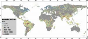
Quantifying fluvial fluxes is a fundamental goal of earth-system science. Ongoing measurements of riverine Water, Sediment and Nutrient fluxes to the oceans are limited (<10% of rivers) and intra-basin measurements are even scarcer. Numerical models provide a useful bridge to this measurement gap and offer insight to past and future trends in response to human and environmental changes.
We developed and use the WBMsed model to study the impacts of Climate Change, Land Use Dynamics, and Manmade Structures (e.g. Dams) on large river systems worldwide. WBMsed is a component within the Framework for Aquatic Modeling of Earth System (FrAMES), a spatially and temporally explicit multi-scale (local through global) hydrological/biogeochemical modeling scheme.
Selected Publications
- Cohen, S., Syvitski, J., Ashely, T., Lammers, R., Fekete, B., & Li, H. Y. (2022). Spatial Trends and Drivers of Bedload and Suspended Sediment Fluxes in Global Rivers. Water Resources Research, e2021WR031583. https://doi.org/10.1029/2021WR031583 [pdf]
- Moragoda, N., S. Cohen, J. Gardner, D. Muñoz, A. Narayanan, H. Moftakhari, T.M. Pavelsky, (2023). Modeling and Analysis of Sediment Trapping Efficiency of Large Dams using Remote Sensing. Water Resources Research, 59, e2022WR033296. https://doi. org/10.1029/2022WR033296
- Moragoda, N., S. Cohen, (2020). Climate-induced Trends in Global Riverine Water Discharge and Suspended Sediment Dynamics in the 21st Century. Global and Planetary Change, 191, 103199. [pdf]
- Syvitski, J.P.M., S. Cohen, A.J., Kettner, G.R., Brakenridge, (2014), How Important and Different Are Tropical Rivers? Geomorphology, 227: 5-17. [pdf]
- Cohen,S., A. J. Kettner, and J.P.M. Syvitski (2014), Global suspended sediment and water discharge dynamics between 1960 and 2010: Continental trends and intra-basin sensitivity, Global and Planetary Change, 115: 44-58 [pdf]
- Cohen, S., A. J. Kettner, J.P.M. Syvitski and B.M. Fekete (2013), WBMsed, a distributed global-scale riverine sediment flux model: Model description and validation, Computers & Geosciences. [pdf]
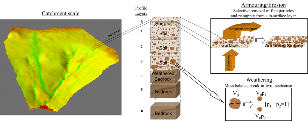
Additional Research Foci
- Soil-Landscape Evolution Modeling
- Gully Evolution Modeling
- River Gauging Stations using Microwave Remote Sensing
- Future Global Land Use Model